![Item #42908 Hudson Tunnel Map and Profil [sic]. [Profile of the first tunnel under the Hudson River, with Certificate]. New York City, Office of the Secretary of State. Hudson Tunnel Railway Company.](https://kaaterskillbooks.cdn.bibliopolis.com/pictures/42908.jpg?width=768&height=1000&fit=bounds&auto=webp&v=1699972082)
![Hudson Tunnel Map and Profil [sic]. [Profile of the first tunnel under the Hudson River, with Certificate].](https://kaaterskillbooks.cdn.bibliopolis.com/pictures/42908_2.jpg?auto=webp&v=1699972082)
![Hudson Tunnel Map and Profil [sic]. [Profile of the first tunnel under the Hudson River, with Certificate].](https://kaaterskillbooks.cdn.bibliopolis.com/pictures/42908_3.jpg?auto=webp&v=1699972082)
![Hudson Tunnel Map and Profil [sic]. [Profile of the first tunnel under the Hudson River, with Certificate].](https://kaaterskillbooks.cdn.bibliopolis.com/pictures/42908_4.jpg?auto=webp&v=1699972082)
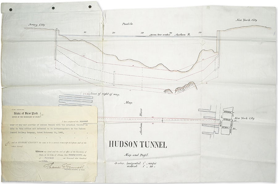
Hudson Tunnel Map and Profil [sic]. [Profile of the first tunnel under the Hudson River, with Certificate].
Albany, NY: State of New York, 1909 (1891). Ink on drafting vellum with colored outlines. 15 x 24 inches. First edition. Very good clean copy with long tear repaired on th verso and tiny chips at one fold on map, inch tear to fore edge of certificate and along bottom margin. Item #42908
Docket sheet mounted to verso. In 1874, the Hudson Tunnel Railroad Company (soon named the Hudson River Railway Company) was formed to construct tunnels between Jersey City and Greenwich Village (the route originally to be about two miles commencing at a point under the Hudson River, in the westerly boundaryline of the state of New York, opposite the foot of Clarkson street, at the termination of the Hudson Tunnel Railroad Company of New Jersey, and thence running by a feasible route under the bed of the river and beneath the surface of the city of New York, to a point at or near the westerly side of Broadway between Prince and Eighth streets; from whence the line proceeds via Sixth avenue to Thirty-third street, New York) but stopped construction well before completion. The assets (land, partially-constructed tunnels, trackage, etc.) were eventually sold to the newly-organized New York & Jersey Railroad (incorporated on February 12, 1902), under the leadership of William G. McAdoo, who was later U.S. Treasury Secretary, and which then became the Hudson and Manhattan Railroad (1906). The original of this profile was drafted in 1891 (before the railroad collapsed), and the present certified copy was prepared by the Secretary of State's office on February 25, 1909, almost exactly one year after the official opening of the tunnel (the Pennsylvania Railroad's North River Tunnels, the second to burrow under the Hudson, did not open until late 1910). The reason that a copy of the map was requested is not known but what is known is that the railroad was seeking to extend the Sixth Avenue line later as well as other related projects. Perhaps the map was needed to settle some land issue or in some legal negotiations as the pencilled word "referee" appears after two sets of initials. The tunnels still carry a heavy load of PATH train commuters between Jersey City and Manhattan. Similar maps are difficult to locate. The closest, a printed "Map of Hudson & Manhattan Railroad Hudson tunnel system, January 1908," is located at the University of Chicago and the Jersey City Historical Society. Provenance: Collection of Gerald J. Levy.
Price: $950.00