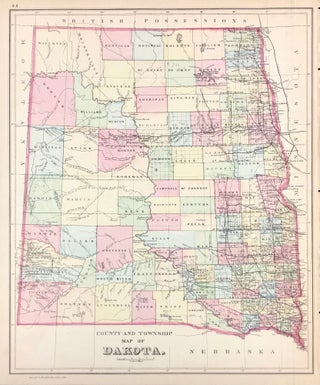
County and Township Map of Dakota.
[Philadelphia]: [W.M. Bradley & Bro.], 1886. Hand colored map. 12 x 14.5 inches. Plate 88: County and Township Map of Dakota. Copyright by Wm. M. Bradley & Bro. 1884. From: Mitchell's New General Atlas, Containing Maps Of The Various Countries Of The World, Plans Of Cities, Etc., Embraced In Ninety-Three..... More
![Item #45724 County and Township Map of Utah and Nevada [with inset] Southern Portion of Nevada....](https://kaaterskillbooks.cdn.bibliopolis.com/pictures/45724.jpg?width=320&height=427&fit=bounds&auto=webp&v=1648505051)
![Item #44576 County Map of the State of California [with] San Francisco [with] San Francisco Bay...](https://kaaterskillbooks.cdn.bibliopolis.com/pictures/44576.jpg?width=320&height=427&fit=bounds&auto=webp&v=1591211713)
![Item #45723 [Map] Colorado [verso with] Indian Territory. S. Augustus Mitchell, Jr](https://kaaterskillbooks.cdn.bibliopolis.com/pictures/45723.jpg?width=320&height=427&fit=bounds&auto=webp&v=1699972098)
![Item #37723 Overland in 1846. Diaries and Letters of the California-Oregon Trail [Two Volumes]....](https://kaaterskillbooks.cdn.bibliopolis.com/pictures/37723.jpg?width=320&height=427&fit=bounds&auto=webp&v=1432524540)
![Item #45859 [Autograph Quote Signed] "God grant your sufferings may never equal mine," from Ann...](https://kaaterskillbooks.cdn.bibliopolis.com/pictures/45859.jpg?width=320&height=427&fit=bounds&auto=webp&v=1699972099)
![Item #46094 [Manuscript] Brigham Young Invites Son-In-Law, George Thatcher & Wife to a Family...](https://kaaterskillbooks.cdn.bibliopolis.com/pictures/46094.jpg?width=320&height=427&fit=bounds&auto=webp&v=1697466359)
![Item #43663 [Photograph] U.S.S. Melville in San Diego, Calif. O A. Tunnell](https://kaaterskillbooks.cdn.bibliopolis.com/pictures/43663.jpg?width=320&height=427&fit=bounds&auto=webp&v=1493665371)