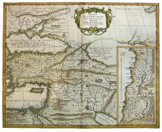
Lumen Historiarum Per Orientem illustrandis Biblijs Sacris, Martijrologio & alijs multis a Fran. Hareio concinnatum.
[Hague]: Pieter de Hondt, [1741]. 379 x 471 mm. Copperplate map with inset map "Iudaeae amplior descriptio" 23.5 x 12.0 cm, showing Palestine, divided among the tribes. Map, inset, borders, and cartouche hand-colored. This map was first published in Ortelius' Parergon 1624. Most likely from the French edition of Jansson's..... More