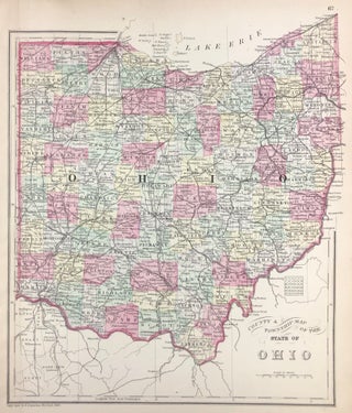
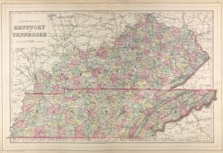
County & Township Map of the State of Ohio.
[Philadelphia]: [W.M. Bradley & Bro.], 1886. Hand colored map. 11.5 x 13.5 inches. Plate 67: County & Township Map of the State of Ohio. Copyright by S. Augustus Mitchell 1884. From: Mitchell's New General Atlas, Containing Maps Of The Various Countries Of The World, Plans Of Cities, Etc., Embraced In..... More
![Item #45724 County and Township Map of Utah and Nevada [with inset] Southern Portion of Nevada....](https://kaaterskillbooks.cdn.bibliopolis.com/pictures/45724.jpg?width=320&height=427&fit=bounds&auto=webp&v=1648505051)
![Item #45709 County Map of the State of New Jersey [verso with] County Map of Pennsylvania...](https://kaaterskillbooks.cdn.bibliopolis.com/pictures/45709.jpg?width=320&height=427&fit=bounds&auto=webp&v=1648505051)

![Item #45713 County Map of the States of Georgia and Alabama [with inset] Savannah, Georgia [and]...](https://kaaterskillbooks.cdn.bibliopolis.com/pictures/45713.jpg?width=320&height=427&fit=bounds&auto=webp&v=1648505051)
![Item #44579 Map of Brazil, Bolivia, Paraguay, and Uruguay (with) Map of Chili [with inset] Harbor...](https://kaaterskillbooks.cdn.bibliopolis.com/pictures/44579.jpg?width=320&height=427&fit=bounds&auto=webp&v=1591211713)
![Item #44580 Map of South America, Showing Its Political Divisions [with inset] Map Showing the...](https://kaaterskillbooks.cdn.bibliopolis.com/pictures/44580.jpg?width=320&height=427&fit=bounds&auto=webp&v=1574191522)
![Item #45723 [Map] Colorado [verso with] Indian Territory. S. Augustus Mitchell, Jr](https://kaaterskillbooks.cdn.bibliopolis.com/pictures/45723.jpg?width=320&height=427&fit=bounds&auto=webp&v=1758648651)
![Item #45706 [Map] France [with insets] Environs of Paris [and] Switzerland in Cantons [and]...](https://kaaterskillbooks.cdn.bibliopolis.com/pictures/45706.jpg?width=320&height=427&fit=bounds&auto=webp&v=1648505051)
![Item #45718 [Map] Indiana. S. Augustus Mitchell, Jr](https://kaaterskillbooks.cdn.bibliopolis.com/pictures/45718.jpg?width=320&height=427&fit=bounds&auto=webp&v=1648505051)
![Item #45714 [Map] North and South Carolina [with insets] Plan of Charleston [and] Map of...](https://kaaterskillbooks.cdn.bibliopolis.com/pictures/45714.jpg?width=320&height=427&fit=bounds&auto=webp&v=1648505051)
![Item #45711 [Map] Plan of Baltimore [verso with] County Map of the States of Delaware, Maryland,...](https://kaaterskillbooks.cdn.bibliopolis.com/pictures/45711.jpg?width=320&height=427&fit=bounds&auto=webp&v=1648505051)
![Item #45704 [Map] Prussia, and the German States [verso with] Map of the Austrian Empire, Italian...](https://kaaterskillbooks.cdn.bibliopolis.com/pictures/45704.jpg?width=320&height=427&fit=bounds&auto=webp&v=1648505051)
![Item #45702 [Map] Russia in Europe, Sweden, and Norway [with insets] Map of Denmark [and] Map of...](https://kaaterskillbooks.cdn.bibliopolis.com/pictures/45702.jpg?width=320&height=427&fit=bounds&auto=webp&v=1648505051)
![Item #45705 [Map] Spain & Portugal. S. Augustus Mitchell, Jr](https://kaaterskillbooks.cdn.bibliopolis.com/pictures/45705.jpg?width=320&height=427&fit=bounds&auto=webp&v=1648505051)
![Item #45719 [Map] St. Louis [verso with] County & Township Map of the States of Iowa and...](https://kaaterskillbooks.cdn.bibliopolis.com/pictures/45719.jpg?width=320&height=427&fit=bounds&auto=webp&v=1648505051)
![Item #45701 A New Map of Palestine or the Holy Land [with inset] Map of Modern Jerusalem [verso...](https://kaaterskillbooks.cdn.bibliopolis.com/pictures/45701.jpg?width=320&height=427&fit=bounds&auto=webp&v=1648505051)