![Item #40378 Amer. Sep. Partie de la Vieille Californie. No. 58. [and] No. 65. Philippe. Humboldt Vandermaelen, Alexander von.](https://kaaterskillbooks.cdn.bibliopolis.com/pictures/40378.jpg?width=768&height=1000&fit=bounds&auto=webp&v=1432524601)
![Amer. Sep. Partie de la Vieille Californie. No. 58. [and] No. 65.](https://kaaterskillbooks.cdn.bibliopolis.com/pictures/40378_2.jpg?auto=webp&v=1432524601)
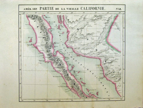
Amer. Sep. Partie de la Vieille Californie. No. 58. [and] No. 65.
[Bruxelles]: [Ph. Vandermaelen], 1827. 2 sheets. Hand-colored lithographic maps. 46 x 51 cm and 46 x 54 cm. First edition. Very good bright copies, a few minor spots or marginal finger soiling. Phillips, 749. Sabin 43762. Item #40378
Large scale map of Baja. Map 58 includes parts of Baja California, Sonora, Sinaloa and Chihuahua. Map 65 includes the tip of Baja California and the "Iles Revillagigedo" and a text box: Note sur le Mexique ... de Humboldt. Sheets from Phillipe Vandermaelen, Atlas universel de geographie physique, politique, statistique et mineralogique..., a magnificent and ground breaking six volume atlas of the entire world, which was the first Atlas to use lithography, to show the entire world using such a large uniform scale, approcimately 26 miles to the inch, and which was designed to be joined together into a three-dimensional globe with a diameter of approximately 25 feet.
Price: $725.00