![Item #41245 [Map] A New and Accurate Map of Anatolia or Asia Minor. Emanuel Bowen](https://kaaterskillbooks.cdn.bibliopolis.com/pictures/41245.jpg?width=320&height=427&fit=bounds&auto=webp&v=1432524618)
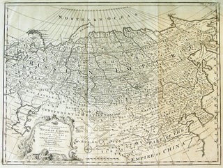
[Map] A New and Accurate Map of Anatolia or Asia Minor.
[London]: [1750]. 42.5 x 35.5 cm. (16.75 x 14 inches). No. 40. Published by Bowen in 1747 in "A Complete System of Geography (and later in a later state in "A Complete Atlas", in 1752 where it appears as No. 35. Tears to the margins, edges ragged, but image very..... More
![Item #41243 [Map] A New and Accurate Map of Peru and the Country of the Amazones. Drawn from the...](https://kaaterskillbooks.cdn.bibliopolis.com/pictures/41243.jpg?width=320&height=427&fit=bounds&auto=webp&v=1432524618)