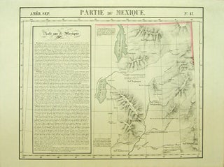
Amer. Sep. Partie de la Vieille Californie. No. 47.
[Bruxelles]: [Ph. Vandermaelen], 1827. 1 sheet. Hand-colored lithographic map. 47 x 57 cm. First edition. Shows the ranges of eight Indian tribes. Covers parts of Utah, Colorado and northern Arizona and New Mexico. Includes text: Note sur le Mexique. At a time when American map publishers were virtually ignoring the..... More
![Item #40377 [Maps] Amer. Sep. Haiti ou St. Domingue. No. 68. [with] Curacao. No. 74. Philippe...](https://kaaterskillbooks.cdn.bibliopolis.com/pictures/40377.jpg?width=320&height=427&fit=bounds&auto=webp&v=1643909946)
![Item #40378 Amer. Sep. Partie de la Vieille Californie. No. 58. [and] No. 65. Philippe. Humboldt...](https://kaaterskillbooks.cdn.bibliopolis.com/pictures/40378.jpg?width=320&height=427&fit=bounds&auto=webp&v=1432524601)